The IMS-GIS data centre is responsible for the development of webGIS** projects which are aimed at informing the wider public on the outcomes from research projects or on the matters that require public consultation. Additionally, webGIS projects can also help collecting data and support citizen science programmes.
Below a list of webGIS project realised up to now (in brackets the last time they have been updated):
**Web GIS is essentially a simplified GIS system that uses web technologies to make data accessible to the public regardless of whether or not they have a background and knowledge about GIS.
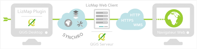
Considering the internet limitations and the resources available (staff and money) that are shared by the UKOTs in the South Atlantic region, it was necessary to adopt a very simple approach for the development of webGIS services.
QGIS is the open source GIS tool used in the Falkland Islands, Ascension and Saint Helena and with the plugin Lizmap provides the simplest platform for creating webGIS services. The steps for publishing online are four:
- Set up the server with GIS, PostgreSQL and web application (Lizmap, Apache, php)
- Create the QGIS project based on data coming from a database (postgresql)
- Use the Lizmap plugin to publish the project online
- Transfer the project and the data from local to the server with the web applications
A general and simple guide (How to use WebGIS) is available to learn how to navigate through the webGIS projects.
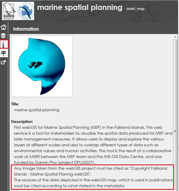
All the data in the webGIS projects have a metadata record in the online catalogue. Since at the moment a direct download of the data displayed on the interactive maps, is not available all users interested in the data should consult the metadata record and email the data request form to either the data custodian or the data owner (as specified in the metadata record).